


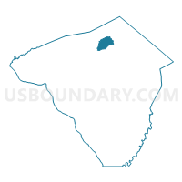
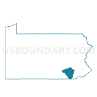
CLAY TWP VTD SOUTH, Lancaster County, Pennsylvania
About
Outline

Summary
| Unique Area Identifier | 660430 |
| Name | CLAY TWP VTD SOUTH |
| County | Lancaster County |
| State | Pennsylvania |
| Area (square miles) | 9.51 |
| Land Area (square miles) | 9.46 |
| Water Area (square miles) | 0.05 |
| % of Land Area | 99.52 |
| % of Water Area | 0.48 |
| Latitude of the Internal Point | 40.21534560 |
| Longtitude of the Internal Point | -76.22923360 |
Maps

Graphs
Select a template below for downloading or customizing gragh for CLAY TWP VTD SOUTH, Lancaster County, Pennsylvania


Neighbors
Neighoring Voting District (by Name) Neighboring Voting District on the Map
- CLAY TWP VTD NORTH, Lancaster County, PA
- ELIZABETH TWP Voting District, Lancaster County, PA
- EPHRATA TWP DIST LINCOLN, Lancaster County, PA
- WARWICK TWP DIST CLAY NEWPORT, Lancaster County, PA
- WEST COCALICO TWP VTD SCHOENECK, Lancaster County, PA
Top 10 Neighboring County Subdivision (by Population) Neighboring County Subdivision on the Map
- Warwick township, Lancaster County, PA (17,783)
- Ephrata township, Lancaster County, PA (9,400)
- West Cocalico township, Lancaster County, PA (7,280)
- Clay township, Lancaster County, PA (6,308)
- Elizabeth township, Lancaster County, PA (3,886)
Top 10 Neighboring Place (by Population) Neighboring Place on the Map
Top 10 Neighboring Unified School District (by Population) Neighboring Unified School District on the Map
- Ephrata Area School District, PA (32,978)
- Warwick School District, PA (31,038)
- Cocalico School District, PA (23,201)
Top 10 Neighboring State Legislative District Lower Chamber (by Population) Neighboring State Legislative District Lower Chamber on the Map
- State House District 37, PA (67,379)
- State House District 97, PA (66,456)
- State House District 99, PA (66,007)
Top 10 Neighboring State Legislative District Upper Chamber (by Population) Neighboring State Legislative District Upper Chamber on the Map
Top 10 Neighboring 111th Congressional District (by Population) Neighboring 111th Congressional District on the Map
Top 10 Neighboring Census Tract (by Population) Neighboring Census Tract on the Map
- Census Tract 101.01, Lancaster County, PA (7,280)
- Census Tract 121.04, Lancaster County, PA (6,066)
- Census Tract 102.02, Lancaster County, PA (5,416)
- Census Tract 124.04, Lancaster County, PA (5,207)
- Census Tract 102.01, Lancaster County, PA (4,778)
- Census Tract 124.03, Lancaster County, PA (4,175)